

Saturday, July 11, 2026
86.45 °f
Magee
  • About Us
  • Our Team
  • Terms of Service
  • Privacy Policy
  • Advertising
  • Contact Us
No Result
View All Result
MageeNews.com
Advertisement
  • Home
  • Message from the Prez
  • News
  • Happenings
  • Obituaries
  • Sports
  • Schools
  • Videos
  • Ducks on the Pond
  • Home
  • Message from the Prez
  • News
  • Happenings
  • Obituaries
  • Sports
  • Schools
  • Videos
  • Ducks on the Pond
No Result
View All Result
MageeNews.com
No Result
View All Result
Home News Mississippi News

NASA’s Stennis Space Center Employs Drones as New Go-To Resource

Patrice Boykin by Patrice Boykin
March 15, 2022
in Mississippi News, News, Uncategorized
0
NASA’s Stennis Space Center Employs Drones as New Go-To Resource

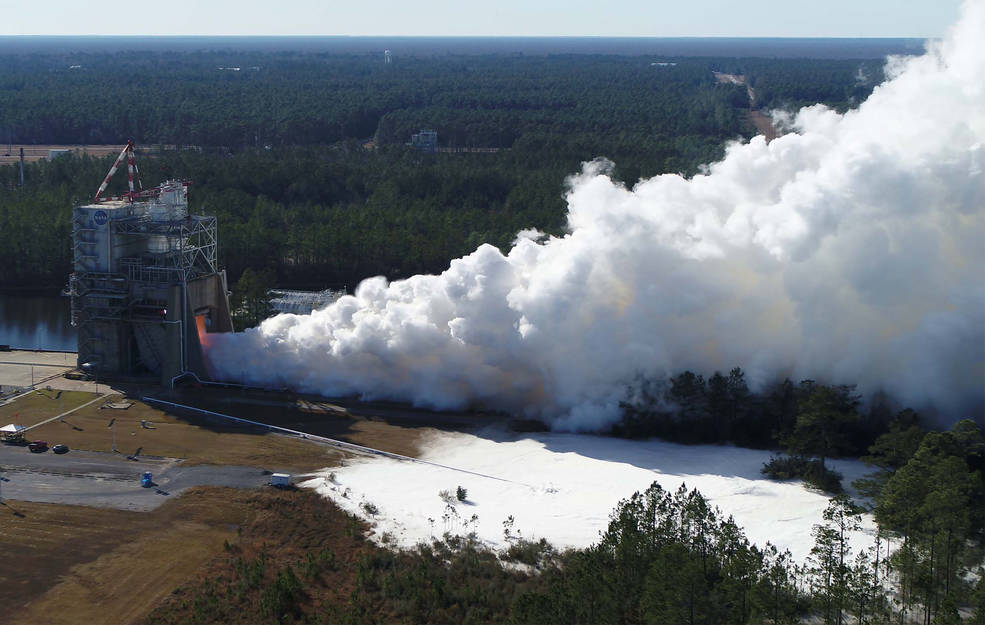
A Stennis Space Center drone captures high quality images and live stream video of an RS-25 test event and its associated liquid oxygen ground disbursement on Feb. 24, 2022. Credits: NASA/SSC

0
SHARES
13
VIEWS
Share on FacebookShare on Twitter

Please note that this post contains affiliate links and any sales made through such links will reward MageeNews.com a small commission – at no extra cost to you.

NASA’s Stennis Space Center Employs Drones as New Go-To Resource

Piloting Unmanned Aircraft Systems, commonly called drones, are not just for fun any longer. At NASA’s Stennis Space Center near Bay St Louis, Mississippi, drones are becoming a go-to resource for use on difficult and potentially dangerous jobs, helping to save time and costs.

One might encounter drone technology as a toy. Small four-propeller drones entertain in households, crashing into assorted items and performing aerial stunts under the remote piloting skill of children. However, NASA’s trained drone pilots are imagining new ways to make small remote aircraft like these useful.

“Stennis is using drone technology to cut costs, increase productivity, and most importantly, reduce risk exposure to personnel,” said Jason Peterson, NASA’s range and aviation operations manager at Stennis. “Drone technology has multiple capabilities and applications. A drone is a tool in your toolkit, and just like every other tool, it has a purpose and limitations, but drones are proving very advantageous in many situations.”


Related posts

Several Arrests Announced by Magee Police Department

Several Arrests Announced by Magee Police Department

July 10, 2026
Boswell Regional Center Honors Director Clint Ashley on His Retirement

Boswell Regional Center Honors Director Clint Ashley on His Retirement

July 9, 2026

Given modern lightweight cameras and other sensors, drones become highly innovative and versatile flying tools. NASA is using drone technology for a variety of reasons, such as aerial imagery, inspections, and mapping.

A Stennis Space Center drone captures high quality images and live stream video of an RS-25 test event
A Stennis Space Center drone captures high quality images and live stream video of an RS-25 test event and its associated liquid oxygen ground disbursement on Feb. 24, 2022.
Credits: NASA/SSC

At Stennis, drone flights recently recorded imagery of the RS-25’s latest test on Feb. 24. The drone captured live stream video of the test event and the liquid oxygen ground disbursement. Information gleaned from the video is instrumental in future test planning by showing how the oxygen behaves at maximum discharge.

A drone captures high quality images of an ongoing project to replace high-pressure water lines in the A Test Complex at Stennis Space Center
A drone captures high quality images Dec. 15, 2021, of an ongoing project to replace high-pressure water lines in the A Test Complex at Stennis Space Center.
Credits: NASA/SSC

Drones at Stennis also track construction progress and record data for historical purposes. The imagery from the aerial cameras provides a high-quality digital record with time marks. For instance, last year, a drone captured the only 4K imagery of the historic hot fire test of NASA’s Space Launch System core stage on the B-2 Test Stand. The hot fire was the most powerful test at Stennis in more than 40 years, and the drone’s 4K imagery provided four times the resolution of high-definition ground cameras.

Drones at Stennis and NASA’s Michoud Assembly Facility in New Orleans also captured imagery of damaged roofs after Hurricanes Zeta and Ida. The aerial imagery gave center leadership the ability quickly to assess the rooftop damage and relay that information to NASA Headquarters in Washington. Using drones to conduct inspections of such hard-to-reach places significantly reduces inspection times.

Stennis Space Center operators use drone images safely to inspect damage to an on-site high-frequency antenna
Stennis Space Center operators use drone images safely to inspect damage to an on-site high-frequency antenna Aug. 13, 2019, also reducing cost and saving time on repairs.
Credits: NASA/SSC

Safety is another significant advantage of drone usage. Drones offer unique capabilities to get close views of potentially life-threatening situations.

“We had an issue with one of the arrays located on our high-frequency antenna,” Peterson said. “The array was damaged and presented a safety issue for personnel on the ground. With the drone, we were able to safely inspect the antenna, figure out the issue, and order a part. This drone footage resulted in cost savings of approximately $10,000, eliminated the exposure risk of personnel climbing the tower, and reduced downtime.”

NASA is not the only organization using drones at Stennis. Currently, NASA and Innovative Imaging and Research have drones that frequently fly the Stennis sky. Depending on each drone’s payload, software, and data collected, drones supply unique, easily deployed vantage points.

“I see drones taking on a larger operations and maintenance role as the technology continues to grow and we expand our program,” Peterson said. “We are looking into expanding payloads and moving towards electro-optical/infra-red operations that will allow us to inspect buildings, critical infrastructures, and utilities such as power lines and substations.”

As NASA integrates drone mapping operations into existing software, future scanning is expected to allow the creation of 2D or 3D real-time maps and models. Each could be able to reach accuracies down to two centimeters. This capability can reduce time and cost compared to traditional surveying.


MageeNews.com is an online news source serving Simpson and surrounding counties as well as the State of Mississippi.
 

Share this:

  • Email a link to a friend (Opens in new window) Email
  • Print (Opens in new window) Print
  • Share on Facebook (Opens in new window) Facebook
  • Share on X (Opens in new window) X
  • Share on Pinterest (Opens in new window) Pinterest
  • Share on LinkedIn (Opens in new window) LinkedIn
  • Share on Reddit (Opens in new window) Reddit
  • Share on Tumblr (Opens in new window) Tumblr
Tags: droneMageeNews.comnasaspacestennis
Previous Post

Lt. Governor Hosemann Proposes Suspension of Gas Tax Amid Record Inflation

Next Post

HYDE-SMITH, COLLEAGUES TARGET ATF ‘SECRET GUIDANCE’ THREAT TO SECOND AMENDMENT RIGHTS

Next Post
Womack Named SCTC Student of the Term

HYDE-SMITH, COLLEAGUES TARGET ATF ‘SECRET GUIDANCE’ THREAT TO SECOND AMENDMENT RIGHTS

Leave a Reply Cancel reply

Your email address will not be published. Required fields are marked *

This site uses Akismet to reduce spam. Learn how your comment data is processed.

Latest News

Several Arrests Announced by Magee Police Department

by Sue Honea
July 10, 2026
0
Several Arrests Announced by Magee Police Department

The Magee Police Department's Patrol Division and Investigation Division reported several arrests made in separate incidents over the past several...

Read moreDetails

South Central Receives National Recognition from the American Heart Association for Rural Stroke Care

by Sue Honea
July 10, 2026
0
South Central Receives National Recognition from the American Heart Association for Rural Stroke Care

LAUREL, Miss. — July 10, 2026 — South Central Regional Medical Center is proud to announce it recently received the...

Read moreDetails

School Board Member Thomas Floyd gives update on Thursday night meeting

by Sue Honea
July 10, 2026
0
School Board Member Thomas Floyd gives update on Thursday night meeting

I offered these remarks to my fellow board members this evening: "First of all,  I would like to say that some...

Read moreDetails
Facebook Twitter Youtube RSS Instagram
MageeNews.com

MageeNews.com is THE source for news and views in Simpson County, Mississippi, and beyond.

Recent News

Several Arrests Announced by Magee Police Department

Several Arrests Announced by Magee Police Department

July 10, 2026
South Central Receives National Recognition from the American Heart Association for Rural Stroke Care

South Central Receives National Recognition from the American Heart Association for Rural Stroke Care

July 10, 2026
School Board Member Thomas Floyd gives update on Thursday night meeting

School Board Member Thomas Floyd gives update on Thursday night meeting

July 10, 2026
Magee, US
Saturday, July 11, 2026
clear sky
86.45 ° f
69%
4.38mh
87.51 f 73.11 f
Sun
81.07 f 70.36 f
Mon
83.43 f 71.02 f
Tue
84.33 f 69.42 f
Wed

© 2023 MageeNews.com

No Result
View All Result
  • Home
  • Sue Stuff
  • News
  • Happenings
  • Schools
  • Sports
  • Obituaries
  • Ducks on the Pond
  • Videos

© 2023 MageeNews.com