

Please note that this post contains affiliate links and any sales made through such links will reward MageeNews.com a small commission – at no extra cost to you.
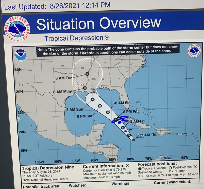
According to Fire Marshal & Emergency Management Director Charlie Valadie, prepare for a possible storm reaching land fall by Sunday night or early Monday morning.
“The direction of the storm is in a constant change,” stated Valadie. Another update will be posted Friday morning that should give us a clearer picture of what lies ahead for the weekend. “Go ahead and fill up your vehicles with gas,” Charlie explained.
National Weather Service Update
Confidence is LOW / MEDIUM / HIGH that the event will occur
Confidence is LOW / MEDIUM / HIGH regarding impacts
TD 9 is in the formative stage, this results in greater uncertainty with the forecast track and potential intensity •
While the official forecast is favorable for potential impacts to our region, details are unknown and will matter
More specifics will be know with later forecasts •
Anticipate updates to our Threat Graphics concerning any potential impacts from wind, flooding and tornado with later forecasts
Current forecast, does put our region is a favorable location to get some impacts ▪ General timing: Impacts could begin as early as Sunday later afternoon/evening, but be mostly Sunday Night into Monday Morning
TD 9 is in the formative stages at this time. ▪ Observation aircraft are in route to investigate the system more and should get more information later this afternoon. ▪ Confidence in the overall forecast, track, intensity, rainfall will increase with time…but at this time uncertainty in the specifics exists
MageeNews.com is an online news source serving Simpson and surrounding counties as well as the State of Mississippi.